Town Planning Society Layout AutoCAD Drawing with Road Widths
Tags
Ratings & Reviews
Be the first to share your experience with this product. Your review helps others make better decisions!
Description
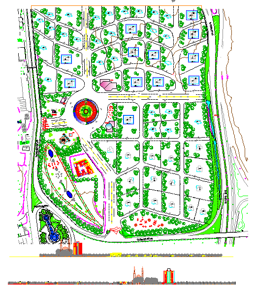
This AutoCAD DWG file illustrates a town planning society layout drawing prepared for residential development and urban planning projects. The drawing clearly shows plotted residential units, internal road networks, junction connections, and organized land distribution within the society. All major elements, such as plot boundaries, road widths, turning radii, and setback lines, are accurately marked with standard measurements in meters, making the file suitable for statutory planning, layout approvals, and execution-level planning. The layout reflects systematic zoning suitable for housing societies and planned urban developments.
The drawing is professionally drafted using standard CAD layers, line types, and annotations to ensure easy readability and modification. It can be directly used by architects, civil engineers, builders, and planners for feasibility studies, proposal submissions, and construction planning. The DWG file is compatible with AutoCAD, 3ds Max, Revit, and Google SketchUp, allowing smooth integration into 2D and 3D workflows. This town planning society drawing is useful for understanding road hierarchy, plot orientation, and spatial organization within a residential township. Downloading this file through a Cadbull subscription provides access to a ready-made planning reference with precise dimensions and clean drafting quality.

Uploaded by:
john kelly
Tags
Ratings & Reviews
Be the first to share your experience with this product. Your review helps others make better decisions!