AutoCAD Housing Scheme Layout with Plot Sizes and Area Details Plan

Ratings & Reviews
Be the first to share your experience with this product. Your review helps others make better decisions!
Description
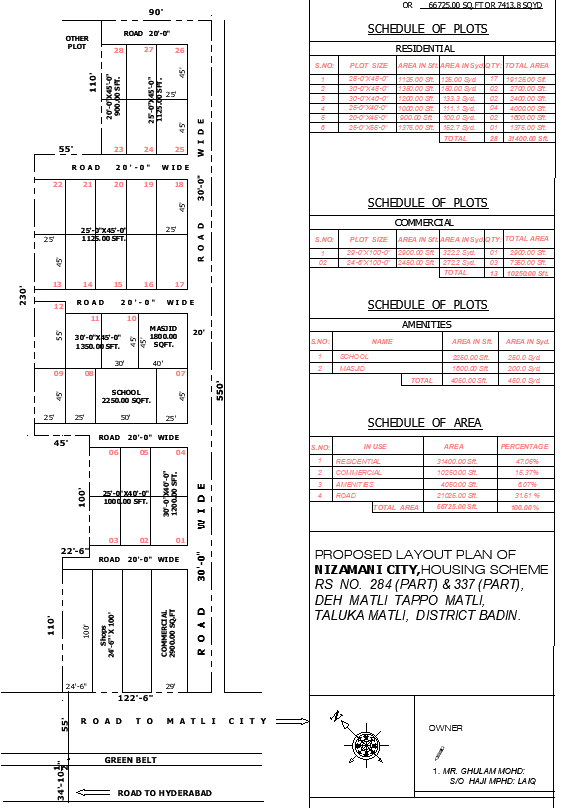
This AutoCAD housing scheme layout provides a complete overview of the Roopkari and Nizamani City plan, showing detailed plot dimensions, area distribution, and site boundaries for architects, civil engineers, and planners. The drawing includes total scheme measurements of 66725 sqft or 1 acre 21.27 ghuntas, with open land sections measuring 98756 sqft or 2 acre 11 ghuntas. Roads surrounding the site include 30 ft wide, 20 ft wide, and 90 ft wide access routes leading toward Hyderabad, Matli city, and Mirpurkhas. The commercial plots are shown with accurate sizes such as 30 ft by 40 ft (1200 sqft), 25 ft by 45 ft (1125 sqft), 20 ft by 45 ft (900 sqft), and larger commercial units measuring 29 ft by 100 ft (2900 sqft). Green belt areas of 61550 sqft and road networks of 230 ft, 110 ft, 100 ft, and 55 ft widths are clearly marked.
Residential plot schedules include sizes such as 25 ft by 45 ft (1125 sqft), 30 ft by 45 ft (1350 sqft), and 25 ft by 55 ft (1375 sqft), making this plan ideal for detailed township planning. Amenities, including a 2250 sqft school and an 1800 sqft masjid, are positioned within the scheme for community accessibility. The layout also features clear labeling of boundaries, livestock zones, agricultural land, and commercial corridors. This AutoCAD layout is highly valuable for professionals seeking precise and ready-to-use planning data for urban development and land subdivision projects.
Tags
Uploaded by:
Neha
mishra
Ratings & Reviews
Be the first to share your experience with this product. Your review helps others make better decisions!